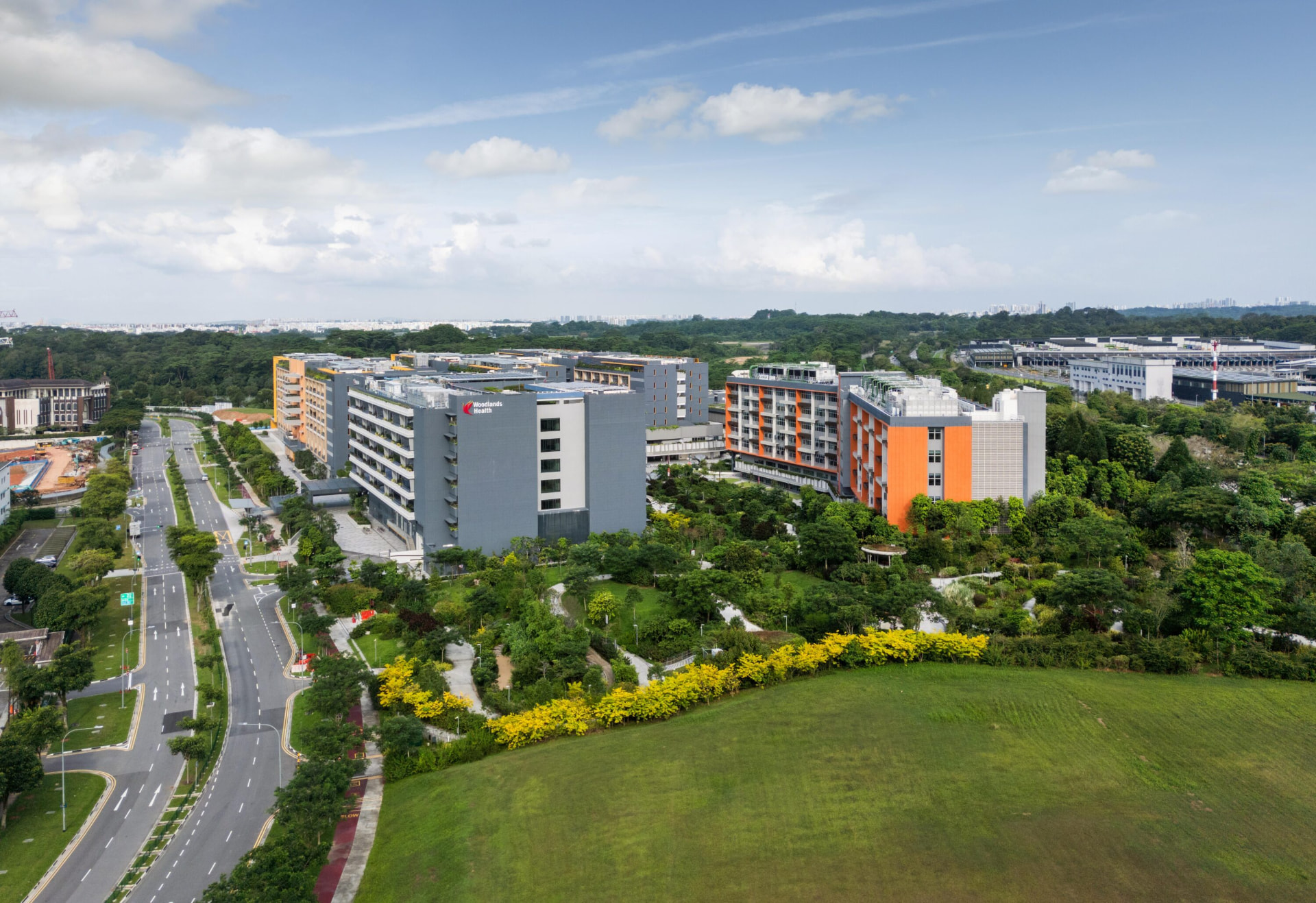
Situated on a 7.7-hectare parcel in northern Singapore, the campus is bounded by Woodlands Drive 17, Woodlands Avenue 12 and the Seletar Expressway (SLE). It is integrated into the neighbouring residential area and directly connected to Woodlands South MRT station through an underground link. The site strategy, the project's most important decision, has permanently locked in the hospital's orientation, block depth and central parkland layout from the start.
Site context
Location, orientation & prevailing winds
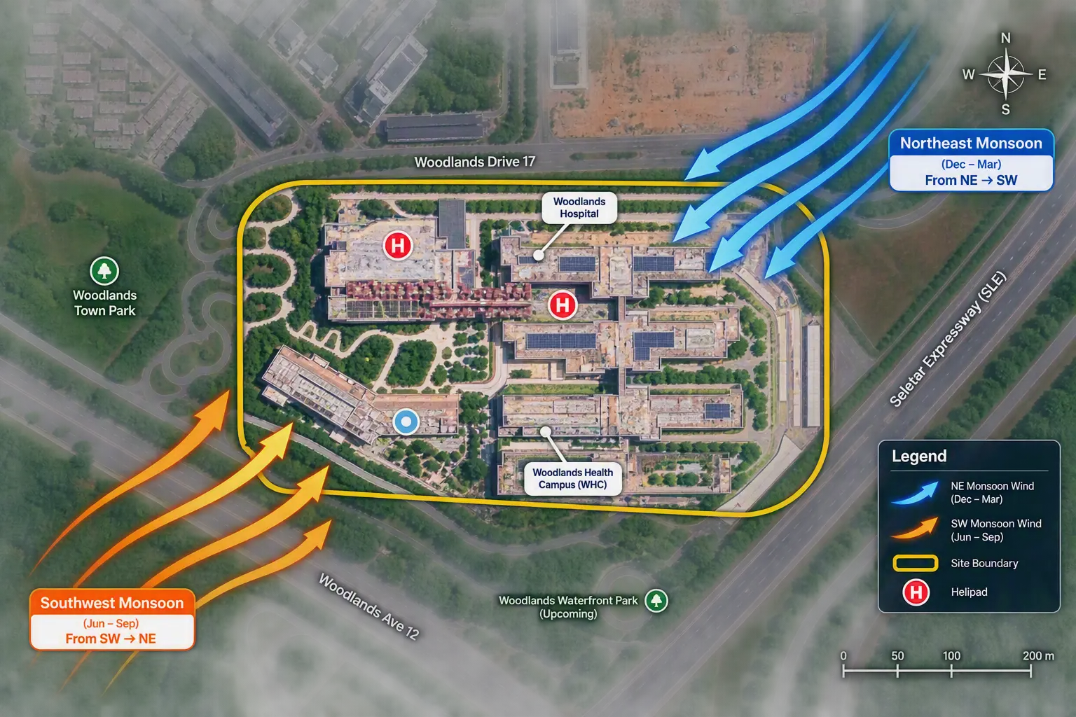
Looking at the aerial view of the campus, the yellow boundary encloses an integrated acute and community hospital, outpatient medical centre, long-term care facility and a therapeutic garden.
Most buildings of the campus are oriented in North-South direction, whereas Long Term Care tower sits on the southern edge of the site is oriented in North-East direction.Image: AI-assisted generation, based on information from publicly available online sources.
Monsoon wind directions
Located in northern Singapore, Woodlands Hospital benefits from the prevailing Northeast Monsoon (Dec to Mar) and Southwest Monsoon (Jun to Sep) wind systems. The campus masterplan and building arrangement are designed to maximise natural airflow through landscaped courtyards, open corridors and interconnected public spaces. The predominantly north-south building orientation helps capture prevailing breezes, enhancing outdoor thermal comfort, supporting passive ventilation and reducing reliance on mechanical cooling in semi-open areas.
Solar orientation
Situated close to the equator, Singapore experiences consistently high solar exposure throughout the year. Woodlands Hospital adopts a predominantly north-south building orientation, minimising low-angle east and west solar heat gain on patient wards and occupied spaces. Combined with deep overhangs, facade shading, sky terraces and extensive greenery, the design reduces cooling loads while improving visual comfort and energy performance.
Planning strategies
Six moves the site makes before the building does
Hover or tap a card to reveal the key points behind each planning strategy.
Location & Accessibility
Strategically located within the Woodlands regional centre, the campus serves the growing healthcare needs of northern Singapore. The development is well connected to major transport corridors, public bus services, MRT networks and surrounding residential precincts. Dedicated drop-off zones, emergency vehicle access routes, service roads, and sheltered pedestrian connections ensure safe and efficient movement for patients, visitors, staff and logistics operations.
Regional healthcare hub for northern Singapore.
Excellent connectivity to public transport.
Segregated public, service and emergency circulation.
Universal accessibility and barrier-free design.
Building Orientation & Massing
The hospital blocks are configured as slender building forms aligned primarily along the north-south axis. This arrangement minimises direct solar exposure on the longer facades while facilitating natural daylight penetration and cross-ventilation opportunities. The spacing between blocks allows wind movement through the campus and preserves views of surrounding greenery, creating a more comfortable and healing environment.
Reduced solar heat gain.
Improved daylight access.
Enhanced air circulation.
Greater patient exposure to natural views.
"Park in Campus" Landscape Concept
A defining feature of Woodlands Health Campus is its "Park in Campus" philosophy, which integrates healthcare and nature into a seamless healing environment. A continuous landscaped spine links major hospital functions, therapeutic gardens, rehabilitation spaces and community areas. The extensive greenery improves biodiversity, reduces urban heat island effects and provides restorative environments that support physical and mental well-being.
Therapeutic and healing gardens.
Integrated community and wellness spaces.
Biodiverse landscape network.
Enhanced patient recovery experience.
Building Height & Operational Efficiency
Unlike conventional high-rise hospitals, Woodlands Health Campus adopts a more horizontally distributed campus arrangement. This planning strategy improves connectivity between healthcare departments, provides greater access to daylight and greenery and creates human-scaled environments. Operational efficiency is supported through underground logistics systems, dedicated service routes and integrated transport infrastructure that minimise disruption to patient-facing areas.
Longer travel distances offset by efficient logistics planning.
Increased accessibility to outdoor spaces.
Improved patient and staff experience.
Better integration with landscape and community facilities.
Noise Mitigation & Buffer Zones
Major ward blocks are positioned away from the site's busiest road corridors. Landscape buffers, green setbacks, courtyards, and lower-intensity support functions are strategically located along road-facing edges to reduce traffic-related noise impacts. This planning approach creates quieter healing environments for patients while improving outdoor comfort across the campus.
Vegetated acoustic buffers.
Building setbacks from expressways.
Internal courtyards as protected spaces.
Reduced noise exposure for patient wards.
Topography, Water & Green Infrastructure
The campus incorporates sustainable water-sensitive urban design principles to manage stormwater and enhance environmental performance. Bio-retention features, rain gardens, planted terraces and extensive landscaping help slow stormwater runoff, improve water quality and mitigate surface heat accumulation. The integration of greenery with water management contributes to a resilient and climate-responsive healthcare environment.